There are high-altitude destinations in India that are famous, and then there is Spiti, a place that seems to exist at the edge of what the planet considers habitable, where brown mountains rise thousands of metres out of a river valley, where Buddhist monasteries cling to cliffsides as if daring gravity, and where the sky at night holds more stars than most people see in a lifetime.
Spiti Valley in Himachal Pradesh sits at an average altitude of 4,000 metres above sea level. The name means "the middle land" — positioned geographically between India and Tibet, and culturally between Hinduism and Tibetan Buddhism. It receives less than 170mm of rainfall annually, making it one of the driest inhabited places in India. The population of the entire valley is around 10,000 people, spread across settlements separated by hours of mountain driving.
The 2026 season has just opened. The first four to six weeks of the season offer the lowest crowds, freshest roads, and the specific quality of light that comes when snow is still visible on the peaks but the passes are clear enough to drive. This guide is your complete reference for planning a Spiti Valley trip in 2026.
Spiti has been on the radar of Indian adventure travellers for over a decade, but 2026 marks a notable shift, improved road connectivity, new accommodation options in Kaza, and growing solo and group travel interest have made it more accessible without yet making it crowded.
The first weeks after the season opens (typically late April to early May) are considered by experienced Spiti travellers to be the best period: roads are freshly cleared, the valley feels private, wildflowers begin appearing in higher meadows, and the temperature, while cold at night, is manageable during the day.
Spiti is not a beach destination or a temple circuit. It is a landscape destination, a photography destination, a slow-travel destination, and for many visitors, a quietly transformative one.
Detail | Information |
|---|---|
Location | Lahaul and Spiti district, Himachal Pradesh |
Average altitude | 3,800–4,500 metres |
Kaza altitude | 3,800 metres |
Season | Late April – October (Manali route), October – March (Shimla route — with 4WD) |
District HQ | Kaza |
Nearest airport | Bhuntar (Kullu–Manali Airport), ~300 km |
ILP required | No (for Indian nationals) |
Best time | May–June and September–October |
This is the first decision every Spiti traveller must make, and it genuinely shapes the entire trip.
Distance from Manali to Kaza: ~196 km
Drive time: 8–12 hours depending on road conditions
Altitude of Rohtang Pass: 3,978 metres
Altitude of Kunzum Pass: 4,551 metres
Season: Open late May to October (snowfall closes passes before and after)
The Manali route is the classic Spiti entry. It crosses two high mountain passes, Rohtang and Kunzum — and involves the most dramatic mountain driving in the entire Himalayan circuit. The road passes through the Lahaul Valley, alongside glaciers, rivers, and landscapes that have no equivalent in populated India.
The road quality is rough. Very rough in sections. A 4WD or high-clearance SUV is strongly recommended, though many travellers do complete it in sturdy hatchbacks. Bikes (especially Royal Enfield Himalayan or similar adventure bikes) are extremely popular on this route.
Who should take the Manali route: Adventure seekers, bikers, first-timers who want the full dramatic experience, and those visiting in summer.
Distance from Shimla to Kaza: ~420 km
Drive time: 12–16 hours over 2 days (recommended to stop at Sangla Valley or Nako)
Key towns en route: Rampur, Pooh, Nako, Tabo, Kaza
Season: Open most of the year (4WD needed in winter months)
The Shimla route is longer but significantly more scenic and culturally rich. It follows the Sutlej and Spiti rivers through Kinnaur, a district famous for apple orchards, wooden temples, and one of the most beautiful river canyon drives in the world. The road hugs sheer cliff faces for long stretches, with the river hundreds of metres below. It is not for the faint-hearted but it is spectacular.
This route also passes through Tabo, a village containing a monastery founded in 996 AD, one of the oldest continuously functioning monasteries in the Himalayan region. Tabo is worth a full stop regardless of which route you take.
Who should take the Shimla route: Those with more time, cultural travellers, repeat visitors to Spiti, and anyone doing a full Spiti circuit (in one side, out the other).
The ideal Spiti trip enters via one route and exits via the other, forming a complete circuit. Most travellers enter via Manali (dramatic, faster, higher passes) and exit via Shimla (slower, more culturally layered). This requires no doubling back and gives you the complete Spiti experience.
For Indian nationals: No Inner Line Permit is required for Spiti Valley.
For foreign nationals: A Protected Area Permit (PAP) is required for certain areas of Spiti near the Indo-Tibetan border, specifically for visiting Kibber, Tashigang, Gete, and Chicham villages, and the area around Hanle (in Ladakh, not Spiti, but often conflated). For the main Spiti circuit — Kaza, Key, Langza, Komic, Chandratal — no permit is needed for foreign nationals.
Always verify the latest permit requirements before travel, as border area restrictions in Himachal Pradesh and Ladakh are subject to change.

Kaza is the district headquarters of Lahaul and Spiti, and the practical base for all Spiti exploration. It sits at 3,800 metres on the banks of the Spiti River.
Do not expect a hill station in the conventional sense. Kaza is a small town of approximately 4,000 people, with a main market street, a cluster of cafes and guesthouses that have improved dramatically in the last five years, a fuel station (important, fill up here), and a government administration. It is functional, friendly, and increasingly comfortable for travellers.
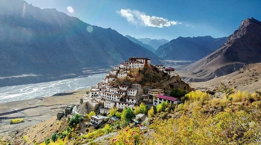
Key Monastery (Kee Gompa) Located 12 km from Kaza at 4,166 metres, Key Monastery is the largest and most visited monastery in Spiti. Founded in the 11th century and rebuilt multiple times after Mongol and Sikh raids, it sits on a hilltop above the Spiti River in a position that looks like it was placed there specifically for photographs. Home to approximately 300 monks and an important centre of the Gelug school of Tibetan Buddhism. Entry is free; donations welcome.
Langza Village A small village at 4,460 metres with one of the most iconic views in Spiti — a giant Buddha statue looking out over the valley, surrounded by Himalayan peaks. Langza is also known for marine fossils found in the surrounding fields (the area was an ancient seabed). The walk from the village to the upper ridgeline offers extraordinary views.
Hikkim Village Claims to have the world's highest post office, at approximately 4,400 metres. You can send postcards from here — they arrive with a special Hikkim postmark, and this has become a genuine travel ritual for Spiti visitors. The post office is functional (bring stamps or buy them there).
Komic Village At approximately 4,520 metres, Komic is one of the highest inhabited villages connected by motorable road in the world. It has a small monastery and extraordinary panoramic views. The drive up is steep and rough but the reward is proportional.
Dhankar Monastery and Lake One of the most dramatic sites in the entire valley — a 1,000-year-old monastery perched on a pinnacle above the confluence of the Spiti and Pin rivers. The walk from Dhankar village to Dhankar Lake (about 2 km uphill) rewards with a perfectly still high-altitude lake reflected against mountain peaks. One of Spiti's finest short treks.
Pin Valley National Park A side valley off the main Spiti Valley, Pin Valley is a snow leopard habitat and one of the best places in India to spot the elusive cat (with patience and a local guide). The valley also has excellent trekking routes and is far less visited than the main Spiti circuit.

Chandratal (the Moon Lake) sits at 4,300 metres and is one of the most beautiful high-altitude lakes in India. It is accessed via a 14 km dirt road that branches off the Manali–Kaza highway near Batal, and then a short 1 km walk to the lake.
The lake is a deep, clear crescent of blue-green water surrounded by scree slopes and distant snow peaks. At sunrise and sunset, the colours shift through ranges that justify every Instagram cliché ever written about it.
Practical details for Chandratal:
Kaza sits at 3,800 metres. Many places you will visit are above 4,000 metres. Chandratal is at 4,300 metres. Kunzum Pass is at 4,551 metres.
At these altitudes, the oxygen level is approximately 40% lower than at sea level. This is not metaphorical — it physically affects your body in ways you cannot always predict, regardless of your fitness level.
Do not rush your ascent. The most common mistake is driving from Manali (2,050 metres) to Kaza (3,800 metres) in a single long day and immediately doing strenuous activity. Give your body at least one full rest day at Kaza before visiting higher sites.
Stay hydrated. Drink 3–4 litres of water per day. Avoid alcohol for the first two days at altitude — it significantly worsens acclimatisation.
Consider Diamox (Acetazolamide). A preventive medication that speeds acclimatisation. Requires a prescription — consult your doctor at least a week before departure. Common dose is 125–250 mg twice daily starting the day before your ascent.
Ascend gradually. The principle is "climb high, sleep low." Visit Langza or Komic by day, return to Kaza (lower) to sleep. Do not sleep at Chandratal (4,300 m) on your first night in the valley.
Know when to descend. If symptoms worsen rather than improve after 24 hours of rest, or if you develop confusion, difficulty walking, or breathlessness at rest — these are signs of serious altitude illness. Descend immediately to a lower altitude.
Fly or bus to Manali (2,050 metres). Rest for the day. Acclimatisation begins here — even at 2,050 metres, your body starts adjusting. Do not attempt strenuous treks. Eat light. Sleep well.
Start at 5:00 AM. This is the big mountain drive. Cross Rohtang Pass (3,978 m) and Kunzum Pass (4,551 m). Stop at Chandratal if road conditions allow (or save for Day 4). Arrive Kaza by late afternoon. Rest immediately — do not exert yourself on arrival at 3,800 metres. Drink water. Eat light.
Do not skip this day. Walk slowly around Kaza town. Visit the local monastery. Have tea. Read. Let your body adjust. If you feel fine by afternoon, a gentle walk to the nearby fields is acceptable. This day determines whether the rest of your trip is enjoyable or miserable.
Start at 9 AM. Visit Key Monastery first (12 km from Kaza). Then drive up to Langza (Buddha statue, fossil hunting, extraordinary views). Continue to Hikkim for the post office ritual. Return to Kaza via Komic for the high-village views. Full day: 60–70 km of mountain driving.
Morning drive to Dhankar (70 km from Kaza). Visit the monastery and walk up to Dhankar Lake (2 km uphill, 45 minutes). Descend and drive to Pin Valley — explore the valley and river. Return to Kaza. Optional: stay overnight at a guesthouse in Pin Valley for an early morning wildlife walk.
Early start (7 AM). Drive toward Batal on the Manali road (about 60 km from Kaza). Take the rough 14 km turnoff to Chandratal base, then walk 1 km to the lake. Spend 2–3 hours. Return to Kaza or drive to Batal/Chatru for overnight camping if weather is good.
Begin the exit via the Shimla route. Tabo (1.5 hrs from Kaza) — spend 30–45 minutes at the ancient monastery before the drive. Continue through Nako and the Kinnaur River Canyon. Stop at Sangla Valley if time allows (beautiful apple orchards and wooden temples). Reach Reckong Peo or Rampur for overnight, then drive to Shimla the following morning.
Category | Budget | Mid-Range | Comfortable |
|---|---|---|---|
Transport (Manali–Spiti–Shimla, shared taxi / bike rental) | ₹3,000–5,000 | ₹8,000–15,000 | ₹18,000–30,000 |
Accommodation (7 nights) | ₹3,500–7,000 | ₹10,000–21,000 | ₹28,000–56,000 |
Meals (7 days) | ₹2,000–3,500 | ₹4,000–7,000 | ₹8,000–14,000 |
Chandratal camping | ₹800–1,500 | ₹1,500–3,000 | ₹3,000–6,000 |
Miscellaneous (fuel, entry fees, guides) | ₹1,000–2,000 | ₹2,000–4,000 | ₹4,000–8,000 |
Total (per person) | ₹10,300–19,000 | ₹25,500–50,000 | ₹61,000–1,14,000 |
Budget figure assumes shared taxis/buses, homestays, and basic guesthouses. The budget range is very achievable if you travel in a group of 3–4 and share transport costs.
Spiti Valley rewards patience and punishes rush. It is a destination that makes no concessions to the traveller who wants convenience; the roads are difficult, the altitude is real, the infrastructure is basic, and the distances are long. These are not bugs. They are features. They are precisely why Spiti remains one of the few places in India where you can still drive for an hour and see nobody but a yak herder on a hillside.
Go in 2026. The season is open. The passes are clear. And the valley is waiting.
Get updates, exclusive deals, insider tips & special offers—straight to your inbox!
 USA: +1 (415) 718-2654
 IND: +91 9629929970
 IND: +91 9629929970
 USA: +1 (415) 718-2654